
HEC-RAS modelling
Familiarisation with the HEC-RAS model:
HEC-RAS Familiarisation Activities – Critical Creek and Spring Creek
These activities are assessable and are included as a way for you to trial the HEC-RAS software before embarking on the road crossing analysis (See Section 3). Refer to Section 4 on the submission requirements for this part of the assignment.
The familiarisation activity is based on the Critical Creek and Spring Creek worked examples outlined in Chapters 1 and 3 of the HEC-RAS Applications Guide. Access the file Introduction to HEC-RAS Modelling from USQ StudyDesk and work through the instructions given.
To document that you have completed the HEC-RAS familiarisation:
- Extract a standard cross section output table for RS 10 for the Existing Conditions run of the Critical Creek HEC-RAS model. The output should be presented in SI units.
- Extract a profile plot of Water Surface Elevations at the culvert for each of the 3 discharges from the Spring Creek HEC-RAS model
HEC-RAS Application – Road Crossing Flood Risk
This part of the assignment involves the establishment and application of a HEC-RAS model of a reach of Caboolture River. Observed flood levels are available to calibrate the HEC-RAS model.
A road crossing is proposed (at cross-section 6) just upstream of the Caboolture River streamgauge. Your task is to determine whether the proposed road crossing is trafficable during the 100 year ARI Major design flood and has sufficient culvert capacity to handle the 10 year ARI Minor design event without overtopping the road.
Design Data and Resources:
Data and resources compiled in order to complete the HEC-RAS modelling are described in Table 1 and can be downloaded from StudyDesk.
The 10 year ARI and 100 year ARI design discharges for the road crossing were determined as part of Assignment 2. The road crossing is required to provide access to a new subdivision development located adjacent to the Caboolture River.
The proposed road crossing has been designed generally in accordance to Main Roads Western Australia Standard Drawing 200131-066. Details of the proposed road crossing are:
- Culvert consists of four (4) identical concrete barrels, each 3.6 metres in diameter
- Culvert inlet invert RL = 6.25 mLD*
- Culvert outlet invert RL = 6.10 mLD*
- Culvert length = 38m
- Road width = 10m
- Road embankment batter slope = 2H:1V
- XS 6 at traverse chainage 466m coincides with culvert inlet
Road overtopping hazard limits should be based on the provisional version of the Queensland Urban Drainage manual (QUDM, 2013). To simply the analysis, assume there are no road traffic barriers (normally this would be included in the hydraulic analysis).
- metres above Local Datum

Application Methodology:
Setup the HEC-RAS model
Setup the necessary HEC-RAS files (project, plan, geometry and flow) that are required to undertake the hydraulic analysis. It is worthwhile checking that there are no obvious problems with the surveyed cross sections – this can be done by preparing cross section plots. An X-Y-Z perspective plot is also useful to visually checking that no major errors have been made in incorporating the surveyed cross sections and the proposed road configuration into HEC-RAS.
Values of key HEC-RAS parameters (Manning’s n, culvert loss coefficients etc) need to be initially selected. Make a list of these parameters with their assumed value as well as a justification of why you have chosen this value. Normally, Manning’s n values are selected from observations of existing channel and overbank conditions made during an inspection of the site. As this is not practical, use the following broad information:
- The left overbank* has native grasses with scattered shrubs.
- The channel banks are densely vegetated with mature trees, predominately camphor laurel, and woody weeds including lantana within the gravelly, channel bed.
- The right overbank is cleared and well grassed, predominately kikuyu pasture.
- Left side when looking downstream
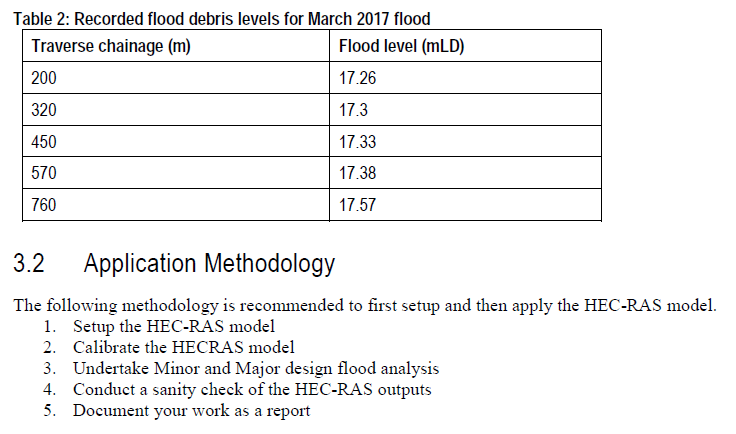
Calibrate the HEC-RAS model
Calibrate the HECRAS model against the recorded March 2017 flood levels. Adjust the Manning’s ‘n’ roughness to match (as best as practicable) predicted and recorded flood level profiles. Report the flood level differences in a table. As the road crossing is yet to be constructed, the calibration will be based on existing (no road crossing) conditions. The observed flood levels are based on surveyed debris levels which inherently have a low accuracy (approx. ± 0.3m).
The Caboolture River streamgauge is located at XS 1. Make use of the rating curve data available at this site for the HEC-RAS model runs, as appropriate, to define the downstream boundary conditions. The rating curve can be found on the Qld Government Water Information Monitoring Portal.
(Hint: Remember that the gauge zero level at the streamgauge is 6m Local Datum, so you will need to add 6 metres to each of the heights in the rating curve to match the surveyed cross-sections.).
Undertake Minor and Major design flood analysis:
Incorporate the initial road crossing into the HEC-RAS model. Run the HEC-RAS model for 10 year and 100 year ARI flood discharges (determined from Assignment 2) assuming steady state flow conditions. Document all assumptions including boundary conditions.
Report the road overtopping flow depths, afflux and velocities and identify if design targets relating to overtopping and hazard limits are achieved with the proposed culvert design.
Report the afflux that results at XS10 as a result of the proposed roadway and culverts.
Sensitivity Analysis
Conduct a sanity check to determine if you haven’t made an error in setting up and running the HEC-
RAS model. Specifically the culvert and road weir flows should be checked. Basic hydraulic formulae
and methods should be used.
Submission
Your submission for Assignment 3 should be in the form of a single file report. The purpose of a file report is to provide a concise record of your work that (hypothetically) can be put on file/archived so relevant information can be recovered at a later date. It is acceptable to use dot points to describe the analyses.
A marking scheme is provided as Table 3. Use this marking scheme to check that you have addressed the full scope of the work. If an element of the assignment has not been documented in the file report than no marks will be given for that element. It is recommended that you structure your report in such a way that each element is clearly and easily identified. Key information such as the methodology that was used, assumptions about analysis inputs and parameters, outputs and results, interpretation of results and recommendations should be included in the file report.
A portion of the available marks has been allocated to reward reporting that is well set out and easy to follow. Submissions that are untidy and/or poorly structured and thus difficult to assess will attract less marks for this element.
Electronic submission of this assignment is required including:
• A single pdf of the report incorporating all appendices
• HEC-RAS files